Recent Trends in Snow Fall

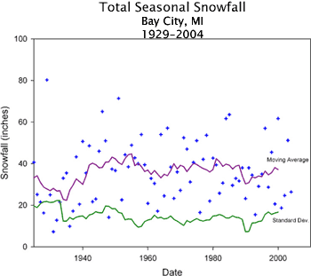
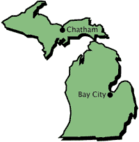
Note the relatively flat trend line for seasonal snowfall totals at Bay City, located on the western edge of Saginaw Bay in the east central Lower Michigan. Snowfall in this area is predominantly of synoptic origin, meaning that the snow tends to be associated with migrating areas of low pressure or other synoptic-scale weather disturbances typically not related to lake-effect snowfall processes.

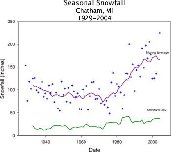
Compare this with seasonal snowfall totals at Chatham, Michigan in the central Upper Peninsula, where snowfall and snow cover amounts have increased dramatically,with almost a doubling of seasonal snowfall in only 20-30 years!

Lake-effect snow is a common cold season phenomenon in the Great Lakes region, occurring most frequently in late autumn and early winter season when temperature differences between cold air and relatively warm lake surface waters are greatest. Cold air is typically transported into the region by northwesterly or northerly winds during this time of year and can be tens of degrees colder than water on the lake surfaces. As the cold air passes over the lakes, it is warmed and moistened by the lake surface waters, which leads to atmospheric instability and the formation of clouds and precipitation. The clouds and snow (rain if air temperatures are high enough) then move downwind, depositing snowfall in areas on the lee shores of the lakes, typically within 100 miles of the lakes themselves.
Lake-effect snow leads to large variability in seasonal snowfall totals across the region based on proximity and direction to the lakes. For example, Detroit, Michigan, on the western (upwind) shore of Lake Erie receives an average of 42 inches per year, while Buffalo, New York, on the eastern (downwind) shore of Lake Erie, receives an average of 92 inches per year.
See: Lake-Effect Snow Climatology in the Great Lakes Region from the Weather Doctor
( http://www.islandnet.com/~see/weather/elements/lkefsnw3.htm )
RETURN TO: Historical Climate Trends ![]()